Welcome to Sky Soaring › Forums › Restricted content › Biden will visit Crystal Lake this Wednesday
- This topic has 3 replies, 3 voices, and was last updated 4 years ago by
 John Phelan.
-
AuthorPosts
-
-
Monday, July 5th, 2021 at 7:40 pm #10785
 John PhelanParticipant
Here you go.
https://tfr.faa.gov/save_pages/detail_1_4173.html
Best Regards,
John F. Phelan
From: Sky Soaring <webmaster@skysoaring.com>
Sent: Monday, July 5, 2021 19:21
To: phelanjf@gmail.com
Subject: [Sky Soaring] New topic: General Discussion, Biden will visit Crystal Lake this Wednesday -
Tuesday, July 6th, 2021 at 10:25 am #10788
 Don GrilloKeymaster
As mentioned, President Biden will be visiting Crystal Lake on Wednesday, July 7, 2021. The FAA has issued a TFR (Temporary Flight Restriction) for this visit. For our students, who may not know what a TFR is and how we as pilots must adhere to that restriction here is a brief synopses.
A Temporary Flight Restriction (TFR) is a type of Notices to Airmen (NOTAM). A TFR defines an area restricted to air travel due to a hazardous condition, a special event, or a general warning for the entire FAA airspace. The text of the actual TFR contains the fine points of the restriction.
Here is a map of the TFR for Wednesday. A TFR also has specific times that they are active and is delineated in the text.
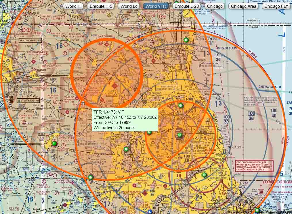
Below is the actual text that the FAA has issued for the TFR. Note that their are 6 areas (A-F) and times covered in this TFR.
For your exercise today, see if you can find Sky Soaring on the map and what Areas and Times it effects us?
Area A Airspace Definition: Center: On the NORTHBROOK VOR/DME (OBK) 174 degree radial at 15.3 nautical miles. (Latitude: 41º58’08″N, Longitude: 87º54’04″W) Radius: 30 nautical miles Altitude: From the surface up to and including 17999 feet MSL Effective Date(s): From July 07, 2021 at 1530 UTC (July 07, 2021 at 1030 CDT) To July 07, 2021 at 1700 UTC (July 07, 2021 at 1200 CDT) Area B Airspace Definition: Center: On the NORTHBROOK VOR/DME (OBK) 174 degree radial at 15.3 nautical miles. (Latitude: 41º58’08″N, Longitude: 87º54’04″W) Radius: 10 nautical miles Altitude: From the surface up to and including 17999 feet MSL Effective Date(s): From July 07, 2021 at 1530 UTC (July 07, 2021 at 1030 CDT) To July 07, 2021 at 1700 UTC (July 07, 2021 at 1200 CDT) Area C Airspace Definition: Center: On the NORTHBROOK VOR/DME (OBK) 279 degree radial at 18.9 nautical miles. (Latitude: 42º15’36″N, Longitude: 88º22’19″W) Radius: 30 nautical miles Altitude: From the surface up to and including 17999 feet MSL Effective Date(s): From July 07, 2021 at 1615 UTC (July 07, 2021 at 1115 CDT) To July 07, 2021 at 2030 UTC (July 07, 2021 at 1530 CDT) Area D Airspace Definition: Center: On the NORTHBROOK VOR/DME (OBK) 279 degree radial at 18.9 nautical miles. (Latitude: 42º15’36″N, Longitude: 88º22’19″W) Radius: 10 nautical miles Altitude: From the surface up to and including 17999 feet MSL Effective Date(s): From July 07, 2021 at 1615 UTC (July 07, 2021 at 1115 CDT) To July 07, 2021 at 2030 UTC (July 07, 2021 at 1530 CDT) Area E Airspace Definition: Center: On the NORTHBROOK VOR/DME (OBK) 174 degree radial at 15.3 nautical miles. (Latitude: 41º58’08″N, Longitude: 87º54’04″W) Radius: 30 nautical miles Altitude: From the surface up to and including 17999 feet MSL Effective Date(s): From July 07, 2021 at 1945 UTC (July 07, 2021 at 1445 CDT) To July 07, 2021 at 2145 UTC (July 07, 2021 at 1645 CDT) Area F Airspace Definition: Center: On the NORTHBROOK VOR/DME (OBK) 174 degree radial at 15.3 nautical miles. (Latitude: 41º58’08″N, Longitude: 87º54’04″W) Radius: 10 nautical miles Altitude: From the surface up to and including 17999 feet MSL Effective Date(s): From July 07, 2021 at 1945 UTC (July 07, 2021 at 1445 CDT) To July 07, 2021 at 2145 UTC (July 07, 2021 at 1645 CDT) -
Tuesday, July 6th, 2021 at 11:27 am #10789John PhelanParticipant
Here is a slightly easier-to-read version. I noticed that 55LL is not listed on the effected airports list. We must be invisible. We used to be listed on these notices but it appears that they now only list Public Use Airports.
Best Regards,
John F. Phelan
From: AOPA <memberservices@mail.aopa.org>
Sent: Tuesday, July 6, 2021 8:43
To: phelanjf@gmail.com
Subject: TFR over Chicago, IL on Wednesday, July 7, 2021To view this email as a web page, click here.


TFR OVER CHICAGO, IL ON WEDNESDAY, JULY 7, 2021

Click the image above to interact with the TFR in iFlightPlanner for AOPANOTAM FDC 1/4173
A NOTAM has been published that will affect flight in the area during President Biden’s planned visit.
30 NM RADIUS TFR
Location
On the NORTHBROOK VOR/DME (OBK) 174 degree radial at 15.3 nautical miles.
From the surface up to but not including 18,000 feet MSL.Times:
10:30 AM CDT until 12:00 Noon CDT Wednesday, July 7, 2021
2:45 PM CDT until 4:45 PM CDT Wednesday, July 7, 202110 NM RADIUS NO-FLY ZONE
Location
On the NORTHBROOK VOR/DME (OBK) 174 degree radial at 15.3 nautical miles.
From the surface up to but not including 18,000 feet MSL.Times:
10:30 AM CDT until 12:00 Noon CDT Wednesday, July 7, 2021
2:45 PM CDT until 4:45 PM CDT Wednesday, July 7, 202130 NM RADIUS TFR
Location
On the NORTHBROOK VOR/DME (OBK) 279 degree radial at 18.9 nautical miles.
From the surface up to but not including 18,000 feet MSL.Times:
11:15 AM CDT until 3:30 PM CDT Wednesday, July 7, 202110 NM RADIUS NO-FLY ZONE
Location
On the NORTHBROOK VOR/DME (OBK) 279 degree radial at 18.9 nautical miles.
From the surface up to but not including 18,000 feet MSL.Times:
11:15 AM CDT until 3:30 PM CDT Wednesday, July 7, 2021Affected Public Use Airports
KORD Chicago O’Hare International Airport
4H1 Schaumburg Municipal Helistop
KPWK Chicago Exec Airport
06C Schaumburg Regional Airport
KMDW Chicago Midway International Airport
KDPA Dupage Airport
1C5 Bolingbrook’s Clow International Airport
C81 Campbell Airport
KLOT Lewis University Airport
3CK Lake in the Hills Airport
TF8 Tinley Park Helistop
KUGN Waukegan Ntl Airport
KARR Aurora Municipal Airport
KGYY Gary/Chicago International AirportKJOT Joliet Regional Airport
10C Galt Field
0C0 Dacy Airport
49C Camp Lake Airport
7V3 Big Foot Airfield
C77 Poplar Grove Airport
C02 Grand Geneva Resort Airport
KUGN Waukegan Ntl Airport
KDKB De Kalb Taylor Municipal Airport
C59 Lake Lawn Airport
KBUU Burlington Municipal Airport
KENW Kenosha Regional Airport
96C Fox River Airport
44C Beloit AirportAdditional Notes:
No UAS operations are authorized in the areas covered by this NOTAM (except as described).
Except as specified below and/or unless authorized by ATC in consultation with the Air Traffic Security Coordinator via the Domestic Events Network (DEN):
A. All aircraft operations within the 10nm radius area(s) listed above, known as the inner core(s), are prohibited except for: approved law enforcement, military aircraft directly supporting the United States Secret Service (USSS) and the Office of The President Of The United States, approved air ambulance flights, and regularly scheduled commercial passenger and all-cargo carriers operations under one of the following TSA-approved standard security programs/procedures and are arriving into and/or departing from 14 CFR part 139 airport: Aircraft Operations Standard Security Program (AOSSP), Full All-Cargo Aircraft Operations Standard Security Program (FACAOSSP), Model Security Program (MSP), Twelve Five Standard Security Program All Cargo (TFSSP-All Cargo), or All-Cargo International Security Procedure (ACISP). All emergency/life-saving flight (medical/law enforcement/firefighting) operations must coordinate with ATC prior to their departure at 847-608-5654 to avoid potential delays.
B. For operations within the airspace between the 10nm radius and 30nm radius area(s) listed above, known as the outer ring(s): all aircraft operations within the outer ring(s) listed abv are limited to aircraft arriving or departing local airfields, and workload permitting, ATC may authorize transit operations. Aircraft may not loiter. All aircraft must be on an active IFR or filed VFR flight plan with a discrete code assigned by an air traffic control (ATC) facility. Aircraft must be squawking the discrete code prior to departure and at all times while in the TFR and must remain in two-way radio com with ATC.
C. The following operations are not authorized within this TFR: flight training, practice instrument approach, aerobatic flight, glider operations, seaplane operations, parachute operations, ultralight, hang gliding, balloon operations, agriculture/crop dusting, animal population control flight operations, banner towing operations, sightseeing operations, maintenance test flights, model aircraft operations, model rocketry, unmanned aircraft systems (UAS), and utility and pipeline survey operations.
D. UAS operations who do not comply with applicable airspace restrictions are warned that pursuant to 10 U.S.C. section 130i and 6 U.S.C. section 124n, the Department of Defense (DOD), the Department of Homeland Security (DHS) or the Department of Justice (DOJ) may take security action that results in the interference, disruption, seizure, damaging, or destruction of unmanned aircraft deemed to pose a credible safety or security threat to protected personnel, facilities, or assets.
E. The System Operations Support Center (SOSC), is the coordination facility for government agencies and is available daily from 0700-2300 eastern, phone 202-267-8276 for coordination.
F. The FAA recommends that all aircraft operators check NOTAMs frequently for possible changes to this TFR prior to operations within this region. Operators may review the TFR details on the internet at https://tfr.faa.gov/ or https://www.1800wxbrief.com. If questions remain, contact flight service at 800-992-7433.

Airspace Online Course
– Take Course –Intercept Procedures Card
– Download Here –
Don’t leave the ground without AOPA’s Pilot Protection Services. We assist in an average of nearly 4,500 aviation-related legal matters annually, including pilot deviations and TFR incursions. Visit here.
You are receiving this TFR notice because you are a member of AOPA. To continue to receive this important member benefit, please keep your membership current and your contact information updated.
Have Questions? Please contact the Pilot Information Center at
1-800-USA-AOPA (872-2672)This TFR email notification is provided as a courtesy and is not an official source to fulfill the pilot in command requirements as stated under 14 CFR 91.103.
For an official briefing please contact Flight Service-1800WXBrief.© 2021 AOPA • 421 Aviation Way Frederick, MD 21701 US
800.872.2672 • 301.695.2375 Fax
Preference Center • Unsubscribe From This Email • http://www.aopa.org
-
-
AuthorPosts
- The forum ‘Restricted content’ is closed to new topics and replies.